Displaying results 1 - 2 of 2
Grid Display
Description
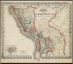
This 1855 map of Peru and Bolivia shows topographical features, cities, towns, forts, rapids, and rivers. National and regional boundaries are marked in pink, green, yellow, and blue. An inset map of ...
Type of Resource
Map
Rights
Colton's Peru and Bolivia. New York: G.W. and C.B. Colton and Company, 1855. Map. Retrieved from the Library of Congress, www.loc.gov/item/2021668481/.

Description
Type of Resource
Map
Rights
All rights reserved. Permission of the Institute Archives and Special Collections required for use and reproduction.
